The Altiplano of South America extends 900km from northern Argentina into southern Peru and takes in large swaths of Chile and Bolivia. Throughout its length its width is between 100-200km with the Andes rising on either side. The altiplano itself lies between 3,500-4,000m and being in the rain shadow from both east and west, receives very little precipitation. It is a bleak, almost treeless area and the southern part – in northern Chile and south west Bolivia, where I visited, is an area of practically uninhabited desert. The altitude produces a cold, dry climate often accompanied by strong winds stirring up dust clouds and adding to the inhospitable nature of the region. Most of the time however, the air is unbelievably clear and the whole plateau is almost always bathed in a bowl of luminous light.
From our initial base at the town of San Pedro in north east Chile, we were in striking distance of the area’s most spectacular sights. Nearest is the surreal landscape of the Valle de la Luna (Valley of the Moon). Aptly named because of its resemblance to a lunar landscape, this is a valley of barren ridges, soaring cliffs and pale valleys. Originally a small corner of a vast inland sea, the valley rose up with the Andes and the water drained slowly away leaving deposits of salt, gypsum and clay without a hint of organic life.
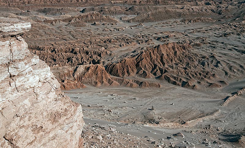
Valle de la Luna, NE Chile
In places there are sand dunes, clay and gypsum hills with the Andean peaks in the background. I am always looking for bands of colour in landscape photography. With a careful eye, it was possible to find an abundance of compositions that met this criteria.
Sand dunes, gypsum and clay hills and distant Andean mountains, Valle de la Luna
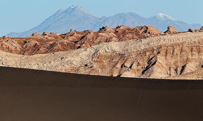
I was also keen to create compositions that included the conical, snow-capped volcanic peak of Licancabur.

Clay hills set against the snow-capped vlocanic peak of Licancabur
Shortly after the sun set, the sky turned a beautiful pastel yellow and the landscape visibly glowed.
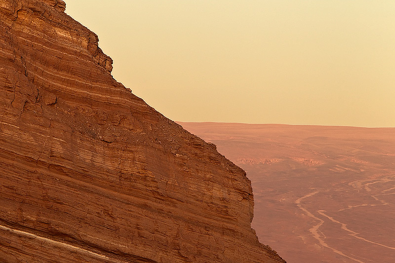
Clay & gypsum cliff face set against the barren floor of the Altiplano, Valle de la Luna, NE Chile
Late in the afternoon on our second day we visited an area of the Salar de Atacama. Within the salt flats there are a number of lakes (Leguna Cejar) and geothermal hot springs in which it is possible to bathe. However, like so much of the area, the towering presence of Lincancabur along with its slightly smaller neighbour, Juriques, loom over the landscape. The areas around the lakes are also home to rare stretches of vegetation in the form of tall grasses. As the sun dipped towards the horizon, the sky turned pink and a cold wind blew through the sunset coloured grass. The following image was created using a shutter speed of three seconds and five stops of graduated neutral density to balance the foreground light with the sky.
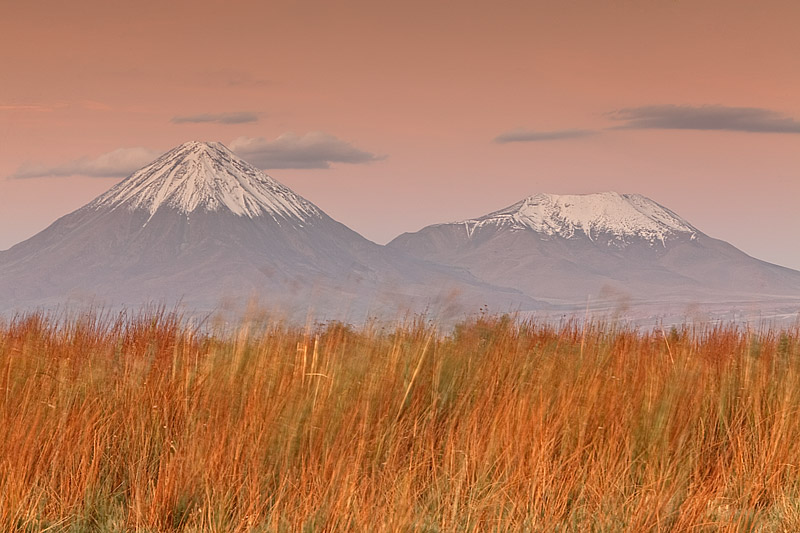
Sunset tinged, windblown grasses with the vlocanic peaks of Lincancabur and Juriques in the background
After three days of getting used to the 8,000 ft altitude at San Pedro, we made a 4.30am start to drive up to 14,000 ft to the Geysers Del Tatio, the world’s highest geothermal field and a breathtaking natural phenomenon. When the the air is still cold (-ve centigrade) in the early morning the geysers throw columns of steam high into the air. While the sight of the dawn sun rays piercing the steam jets is spectacular, I was more drawn to the lichen covered volcanic rocks and the frost covered vegetation that dot the edges of the sulphur-stained geyser field.
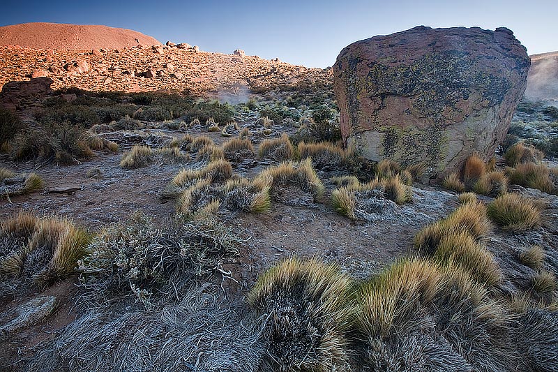
Lichen covered volcanic rock, frost covered grasses and gyser steam, Geysers Del Tatio, NE Chile
As the sun was rising, I dashed around looking for compositions, at times even running. In hindsight, this was not a particularly bright idea at this altitude. Not that later, as our minibus left the area, I began to develop a severe headache accompanied by nausea. The two hour journey back to San Pedro was not enjoyable for me as I constantly had to fight the urge to throw up. Fortunately we were descending. After a few hours back at San Pedro and helped by a liberal dosage of Diamox (altitude sickness medicine), I felt much better. I continued to take Diamox for the duration of the trip and never felt any ill effects again, even when we were up at 16,500 ft in Bolivia.
On our fifth day, we ascended east to the high Altiplano, where we crossed into Bolivia. Here the landscape became even more stark but at the same time, a vista of breathtaking beauty seemed to lie around every corner. This is Lincancabur and Juriques from the Bolivian side. Compared to the abundant snow cover on the Chilean side, note the relatively light cover on the drier Bolivian side.
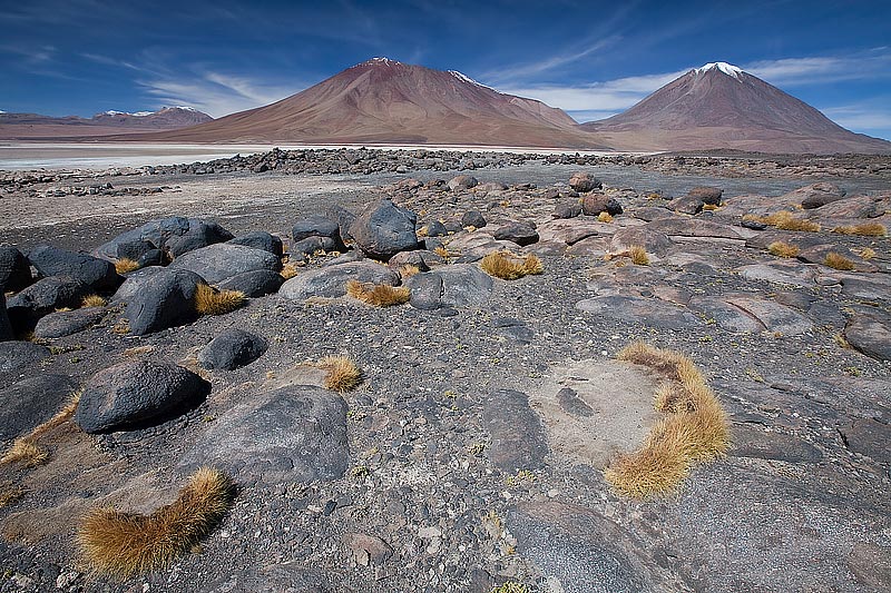
Volcanic rocks, grass tufts and the volcanic peaks of Lincancabur and Juriques, SW Bolivia
Driving north along the Altiplano valley, many of the mountain slopes were covered in rock and soil containing iron ore deposits resulting in distinctive red and orange hues. This is a six frame stitched panoramic image showing this feature.
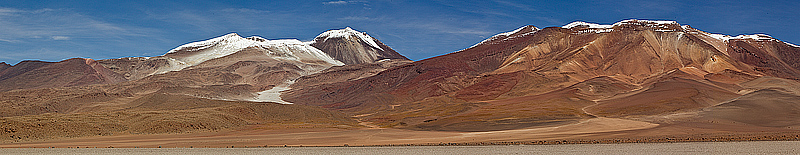
Reddish, orange tinged mountain slopes (from iron ore deposits), SW Bolivia
I have noted the lack of vegetation and certainly green vegetation on the Altiplano. But there is one exception; a large, hard, moss like plant known simply as Rock Plant.
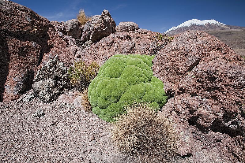
Rock Plant growing on volcanic rock with snow-capped mountains in the background, SW Bolivia
Despite the seemingly inhospitable environment, there is non-avian wildlife on the Altiplano. Vicunas and Guanacos, both of which resemble Llamas are regularly sighted although rarely at close distance. And as we made our through a particularly remote area, we found this inquisitive Andean Fox. With the harsh light and the spectacular backdrop, I chose to use a wide-angle lens to capture this image.
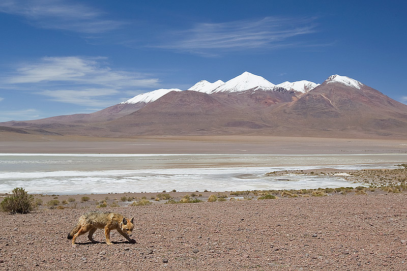
Inquisitive Andean Fox walking in the high altiplano of SW Bolivia
Later in the day as we approached the small town of San Juan, the exclusively barren landscape gave way to the occasional irrigated field of spectacularly coloured quinoa – a vegetable (often mistakenly referred to as a grain) which is rich in protein and minerals and which is becoming increasingly popular among western consumers. Most of the fields contained three varieties of quinoa which bloom in dazzling shades of red, yellow and green. I took many images but the light was less than ideal and I was not really satisfied with any. Photoshop to the rescue. The following image has had a water colour filter run over it (in the “distort” menu under “filters). This has then been taken into Nik’s Colour Efex Pro software where more processing has taken place. The result is a transformation from a rather ordinary photograph to a painting that bears a resemblance to the canvasses of some of the old masters.
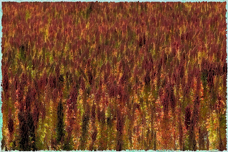
Artistic depiction of a quinoa field outside San Juan, SW Bolivia
After a night in San Juan, we had the chance the next morning to photograph two female Llama herders at work. I’m not sure what they are laughing at in the first image – my guess is that with a bunch of photographers snapping away, she probably felt for the first time in her life like a movie star being pursued by the paparazzi.
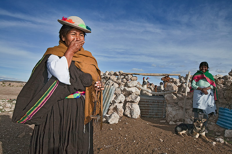
Female Bolivian Llama herders share a joke, San Juan, SW Bolivia
Both of the women were extremely photogenic with wonderful weather beaten faces.
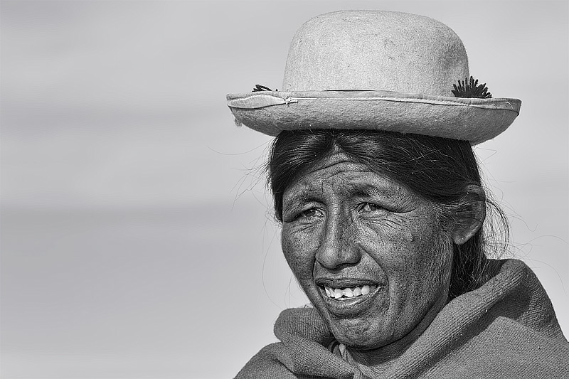
Female Llama herder, San Juan, SW Bolivia
Later, the Llamas were let out of their pens and herded to a nearby water hole.
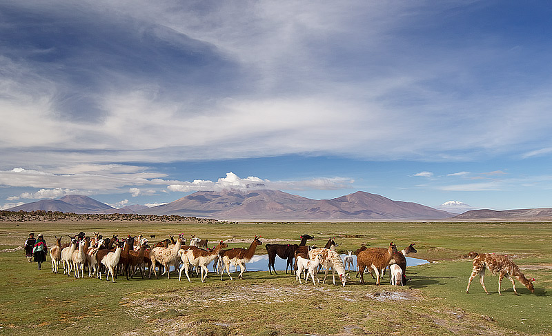
Llama herding near San Juan, SW Bolivia
As the Llamas made their way back to their pen, one of them paused by the water hole with the two herders. With the snow-capped mountain in the background and the reflections on the water, it is one of my favourite images from the trip.
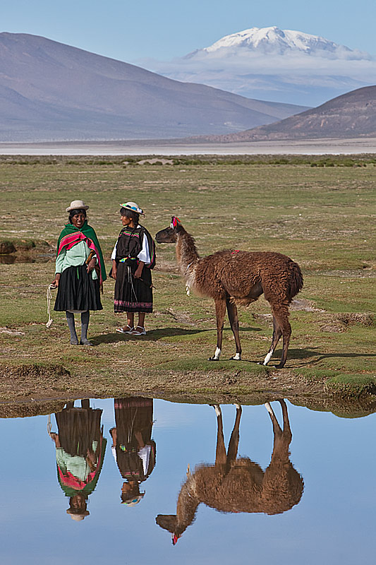
Female Bolivian Llama herders, Llama and reflections at drinking hole with snow capped Andean peak in the background, San Juan area, SW Bolivia
After three days at the Salar de Uyuni (see earlier post), we headed back to Chile. On our last day we headed into Los Flamencos National Reserve. Here we visited a group of eroded volcanic structures called the Pacana Guardians. This is an image of the most distinctive structure and depending on the angle to which it is photographed, can be interpreted in several ways. For me it looks like the face of a Red Indian chief; others managed to come up with a somewhat cruder interpretation.
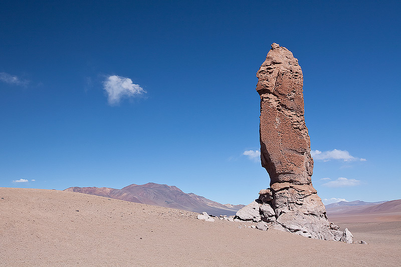
Eroded vlocanic rock structure, Pacana Guardians, Los Flamencos National Reserve, NE Chile
Later we drove to the salt plains of Salar de Pujsa. The area is a mix of water and borax with Flamingos feeding in the saline waters. Sand dunes and barren hills rise up on all sides of the salt plains. As the sun went down, the hills were bathed in golden light, creating patterns of shadow and light as shown in the next image with Flamingos feeding the shallow waters.
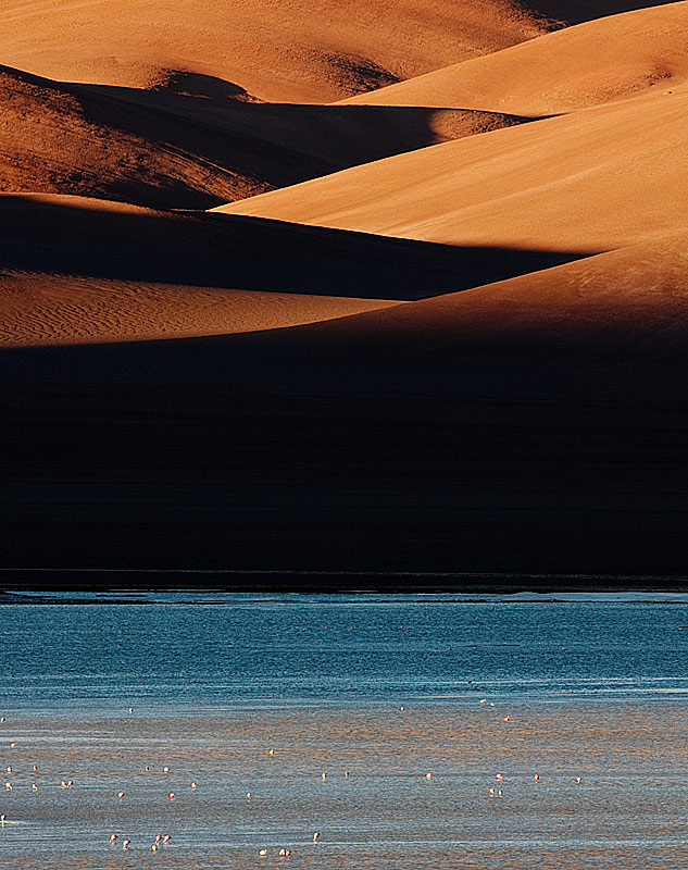
Feeding Flamingos in the shallow waters of Salar de Pujsa, with barren hills and sand dunes in late afternoon light in the background, NE Chile
The waters between the borax deposits then turned a dramatic orange, painted by the light reflected off the hills and dunes. Although by this stage shivering to the bone from one of the coldest winds that I have experienced, it was a memorable way to end a truly amazing trip.
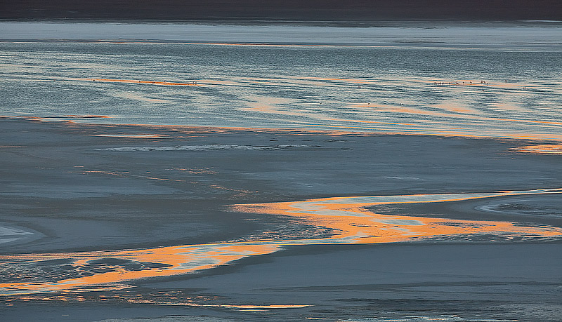
Sunset painted waters between borax deposits on the salt plains of Salar de Pujas, NE Chile
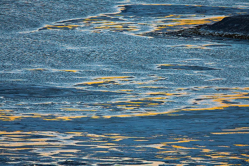
Sunset reflected water on borax covered salt plains at Salar de Pujusa, NE Chile
Coming next: The birds of Midway Atoll
Gail Sermersheim
May 12, 2011
Beautiful. I was there in 1997 and there was a lone fox at the same location as your shot!
Gail Sermersheim (Midway)
jattinn kochhar
May 12, 2011
speechless…….awesome !
Frances
May 12, 2011
spectacular!